Table of Contents
Ted Talk Robert Ballard
CCE LTER Process Cruise-2012
Ocean Explorers Webquest
Sound in the Ocean
Oil Formation Video
Oil Formation Lab
Seismic Exploration Lab
Gnome Oil Spill Modeling Lab
Ted Talk Robert Ballard
CCE LTER Process Cruise-2012
Ocean Explorers Webquest
Sound in the Ocean
Oil Formation Video
Oil Formation Lab
Seismic Exploration Lab
Gnome Oil Spill Modeling Lab
TED Talk Robert Ballard
Today we watched a TED video from Robert Ballard about oceanography and the deep sea. Here are some selected questions and answers based on the video.
What does NOAA stand for?
National Oceanic and Atmospheric Organization
Why are people ignoring the oceans?
People think the ocean is uninteresting or they think it's too dark and scary to explore.
How much bigger is NASA's budget than NOAA's?
1,612 times.
Why do we not have good maps of the ocean?
Few exploring ships go to the remote ocean to make maps of the ocean floor.
How much of the U. S. lies beneath the sea?
50%.
On a good day, how many people are in the deep sea?
4 or 5.
The Mid-Ocean Ridge covers how much of the Earth's surface?
23%.
Why does most of our planet not feel the warmth of the Sun?
Most of the world's surface is the ocean floor, where the water prevents light from reaching it.
What did they find in the deep oceans?
They found found many strange things that nobody had ever seen before, like chemosynthesis, underwater rock formation, hot sulfur vents with life on them, and many weird deep-sea fish.
What is the average depth of the oceans?
12,000 feet.
What is telepresence?
When a ship sends a waterproof camera down to the bottom of the ocean on a wire so that you can see the deep sea without going there.
What is the Okeanos Explorer? What is its mission.
It is a decommissioned Navy ship now used by NOAA. Its mission is to explore and map unexplored parts of the deep sea in U. S. waters with telepresence.
How will it run?
It will be run like a nuclear submarine with 24 hour shifts.
What do you think about living at sea?
It would probably be rough at first and it would take a long time getting used to but eventually it would feel the same as living on land.
Why is it important to explore our oceans?
The oceans have so many amazing things to discover and lesssons to learn about our planet inside of them that it would be dumb not to.
CCE LTER Process Cruise-2012
This assignment was about the blog of a teacher on an ocean exploring expedition, and included questions about the blog. Here are the questions
Day 1
1. Why are scientists particularly interested in the California Current Ecosystem? Why is it special?
It is a coastal upwelling biome, and one of the most productive ecosystems in the world. It sustains active fisheries for a variety of finfish and invertibrates, changes weather patterns and the hydrologic cycle of the Eastern US, and is important in the economy of many coastal towns.
2. What is the name of the research vessel they are on?
The R/V Melville.
3. How much does the ship way when fully loaded?
2526 tons.
Day 3
4. Summarize the process of zooplankton being captured by the MOCNESS.
The MOCNESS consists of 10 nets being sent to different depths, which each one at a different depth and only one open at a time. It catches various plankton from depths ranging to 0 ft. 1500 ft.
5. Explain the vertical migration of many zooplankton species. Why do they do this.
These species go deeper into the water during the day to avoid predators that find food with their eyes. At night, they go back up to the surface to eat phytoplankton.
6. What are phytoplankton?
Tiny plants that float in the water and are eaten by zooplankton.
Day 6
7. What information is colected by the SeaSoar? What are they specifically trying to find?
The SeaSoar collects information about water temperature, salinity and density, dissolved oxygen, and other things to determine how many zooplankton are in the water. They are trying to find the place where the California Coastal Current meets denser coastal water.
8. What does CTD stand for?
Conductivity, Temperature and Depth.
Day 10
9. What is the E-Front?
It is where the California Coastal Current meets inshore currents, so called because it looks like an eddy.
10. Why does the sampling need to be conducted at night?
To ensure that the zooplankton are present at the sampling depth of 300 ft.
11. What is the epipelagic zone?
The light zone of the ocean.

12. These samples were taken along the E-Front. Can you tell where the actual front is located? Tell where you see the sample change.
The sample changes in between the 5th and 6th glasses and in glass 6 itself, so that is probably where the front is located.
13. Explain how chlorophyll samples are preserved.
They are preserved by putting the water into bottles, pouring the water from each one into a different type or size of filter, then collecting the filter papers, preserving them in acetone and then freezing them.
Day 12
14. Where is the mesopelagic zone? Why are the organisms found here special?
A layer of the ocean that is very deep, between 200 and 1000 meters. Organisms that live here are often very strange-looking due to having to adapt to a difficult ecosystem and are hard to bring back alive, and thus are special.
Day 14
15. Explain why styrofoam cups attatched to the CTD shrunk when they where lowered to the depths.
Boyle's law states that if you increase the pressure, you will decrease the volume. When the cups were lowered to the deep zones of the ocean, the increased pressure down there caused the cups to shrink and lose volume.
Day 19
16. Why is iron so important to phytoplankton?
Iron is an nutrient that phytoplankton need and it helps them grow.
17. What kind of precautions are taken by the scientists on board to make sure that the water samples are not contaminated by metals on or around the ship?
They obtain their water from a special clean CTD device covered in plastic to prevent rust, and then put in bottles and pushed with gas through filters.
Day 21
18. How can scientists use poop to determine the biomass of an ecosystem?
They find fecal matter from zooplankton and find the amount of carbon in it, determining the amount of matter, or biomass, flowing through the ecosystem.
19. What is marine smow? How is it collected?
Marine snow is scat and other materials like phytoplankton that fall through the water column. It is collected by lowering vials of salt water that are denser than the salt water so that anything floating down the water column will float into the vials.
Day 24
20. Explain how long-lining is dangerous to marine birds.
Albatross see fish on long-line fishing lines, eat them, and get stuck on the bait and drown.
21. Describe fin whales.
They have a unique coloration and the position of their dorsal fins in relation to their blowholes is different than most whales. They eat larger zooplankton such as krill. They have not been commercially hunted because they are found so far off shore.
Day 26
22. What are copepods and what are they related to?
They are very small zooplankton related to crabs and lobsters.
23. Explain the two ways copepods are studied on this ship.
Their reproduction patterns are studied and pictures are taken of them.
Day 29
24. What is the bow dome? Where is it located?
The bow dome is an area with windows in it in the front of the ship and under the water where you can see the bioluminescence of zooplankton.
25. Would you be interested in spending a month at sea? Does a career in oceanography sound interesting?
I don't think I would like spending a month in sea, though I might be interested in an oceanography career.
26. Which part of this blog was most interesting to you? Why?
I think the parts about the organisms they found were the most interesting, because they taught me a lot about strange, interesting animals that were new to me.
Ocean Explorers Webquest
. List three places in the deep sea visited by ocean explorers within the past three
years.
US Atlantic canyons in the northeast, reefs off the southwest coast of Florida, and the submarine volcanoes of the west Pacific.
2. There are many individuals studying the deep sea or involved with work done
there. List at least five, and describe their fields of research or work they have
done.
Dr. Randy Keller-Marine geologist, studies underwater volcanoes.
Dr. Sandra Brooke-Director of coral conservation, studies coral reefs and helps protect deep ocean life.
Peter Etnoyer-Marine ecologist, finds spots in the ocean with a lot of life and works to conserve them.
Robert Ballard-Oceanographer, explores the deep ocean, making maps and finding new life forms.
Dr. John K. Reed-Marine taxonomist, compiles research and conducts studies on findings.
3. Describe what your day might be like if you were a marine mammal biologist.
Wake up early on research ship in Arctic, set nets up, watch nets for most of day, catch narwhal or other marine mammal, add to group captured and take and record with others, put tracking devices on them and let them go.
4. One of the senior scientists interviewed on the OceanAGE Web page explains the difference between a submarine and a submersible. Find her name and record what she says about this difference.
Catalina Martinez, she says that the difference is that submersibles are not fully autonomous and may rely on a large vessel.
5. What is the name of the fish ecologist who wanted to be an astronaut until he
realized that the ocean was virtually unexplored and the other-worldly creatures
that he wanted to see and study were living right here at home?
Dr. Peter Auster.
6. How do you think that exploring the deep sea is similar to exploring outer space?
Very little of either has been explored and there are many strange and wonderful things to discover in both.
7. Which ocean explorer traces his interest in ocean science to a vacation with his
parents to the Florida Keys when he was five or six and encountered a manatee?
Brian Kennedy.
8. Which explorer looks for marine plants and animals that produce chemicals that can be developed into drugs to treat human diseases?
Dr. Shirley Pomponi.
9. Which marine ecologist looks for “sweet spots” in the ocean, places where life is rich and abundant, and then works with governments and nonprofit organizations to secure protection of those resources for future generations?
Peter Etnoyer.
10. Which ocean explorer was an insect dietician and sonar operator aboard a U.S.
Navy submarine before becoming chief electronics technician aboard the NOAA
Ship Okeanos Explorer?
Richard Conway.
1. Reflect and write about differences and similarities between explorers of the past
and modern day explorers. What types of hardships do both have in common?
In the case of both, they have to leave behind their homes to dedicate themselves fully to their jobs all day, and they have to face failure and setbacks from messed up ventures and failed conjectures.
2. Name some places that have been explored in modern times.
The ocean floor, deep ocean trenches like the Marianas, the moon.
3. Name places that were explored during the early history of humans.
The Americas, Australia, sub-Saharan Africa.
4. Name a place that you have explored. What was unique about it that you think another visitor to that site would not have noticed?
I have explored the canyon near my old middle school. I noticed the different types of trees, the habitats and shelters where animals lived and old remains of tents and food cans where people used to live.
5. Name a place that you would like to explore. What do you think you would find
there? Why?
I would like to explore the rainforests of South America, because I would like to see new kinds of birds and trees.
6. Why is it important to document your explorations? What is your favorite way to
remember your own adventures?
It is important because without documentation it is hard to tell people what you saw and discovered. I like to record things by taking photos and writing in my private journal.
7.
Sound in the Ocean
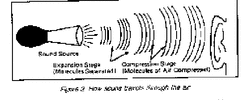
Explain how SOUND travels. (What kind of wave.)
Sound travels in a pressure (p) wave. It vibrates in a wave like pattern throughout a body of air or water.
Sound travels in a pressure (p) wave. It vibrates in a wave like pattern throughout a body of air or water.
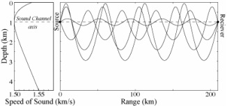
Explain the SOFAR channel.
In the ocean, sound travels fastest at the bottom, and travels fast also at the surface of the ocean. There is a place about 3000 feet down in the ocean where sound travels the slowest. Sound that makes its way to the SOFAR channel stays there for a very long time, not moving from the channel until it hits something. Here sound can travel very far, for over 2000 miles in fact.
In the ocean, sound travels fastest at the bottom, and travels fast also at the surface of the ocean. There is a place about 3000 feet down in the ocean where sound travels the slowest. Sound that makes its way to the SOFAR channel stays there for a very long time, not moving from the channel until it hits something. Here sound can travel very far, for over 2000 miles in fact.
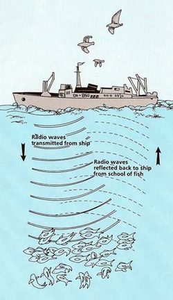
Explain how marine organisms use sound in the ocean.
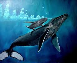
Whales, dolphins, porpoises and other marine mammals use the SOFAR channel to sing their calls in the ocean, therefore allowing them to attract mates and communicate with other animals over long distances, sometimes as long as the distance between California and Hawaii.
Whales, dolphins, porpoises and other marine mammals use the SOFAR channel to sing their calls in the ocean, therefore allowing them to attract mates and communicate with other animals over long distances, sometimes as long as the distance between California and Hawaii.
Explain how people use sound in the ocean.
People use sound in the ocean as SONAR. They send out sound from ships and analyze the sound that echoes back to find out what it bounced off of. They use this to explore the ocean and detect enemy submarines in times of war.
People use sound in the ocean as SONAR. They send out sound from ships and analyze the sound that echoes back to find out what it bounced off of. They use this to explore the ocean and detect enemy submarines in times of war.
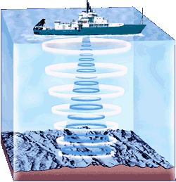
Watch the video and explain how SONAR is used to map the ocean floor.
Boats send out SONAR signals directly to the bottom of the ocean. Then, when the sound comes back, they measure how long it takes for sound in different areas to make it back to the ship and thus measure the depth of these areas. They use this information to make topographical maps of the sea floor
Boats send out SONAR signals directly to the bottom of the ocean. Then, when the sound comes back, they measure how long it takes for sound in different areas to make it back to the ship and thus measure the depth of these areas. They use this information to make topographical maps of the sea floor
Oil Formation Video
1. How long ago did today's oil extract start forming?
About 200 million years ago.
1. How long ago did today's oil extract start forming?
About 200 million years ago.
2. What was the earth like at this time?
There was one large continent, Pangaea. It was surrounded on all sides by ocean.
3. What was oil before it became oil?
Microorganisms, plankton, or other plants/animals whose dead bodies turned into fossils, which eventually turned into oil.
There was one large continent, Pangaea. It was surrounded on all sides by ocean.
3. What was oil before it became oil?
Microorganisms, plankton, or other plants/animals whose dead bodies turned into fossils, which eventually turned into oil.
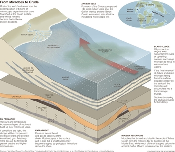
4. This video lists several processes of conditions required to turn dead organisms into oil. List them.
1. Phytoplankton die and sink to the sea floor.
2. Mixes with the sea bed and sinks underground.
3. Other rock layers pressurize/heat the fossils into oil.
4. Oil rises through porous sediment and is blocked/contained by denser rock.
5. Besides oil, what other fossil fuel can be formed by this process with only one minor variation?
Natural gas.
Bonus: Even though there are always plankton to make more oil, it is considered a non-renewable resource. Why?
It takes so long for new oil to form that it cannot be renewed in any reasonable amount of time.
Oil Formation Lab
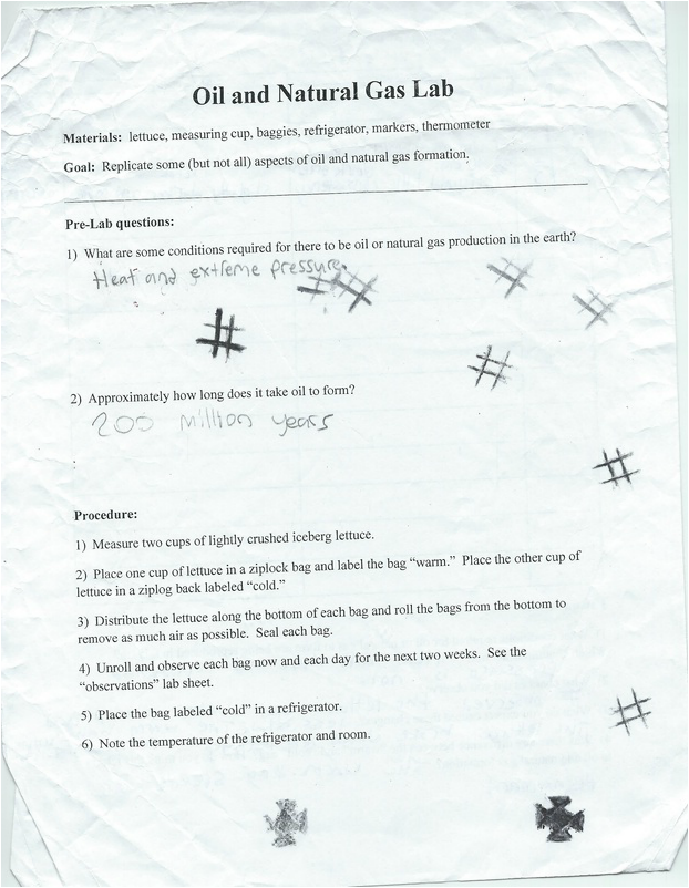
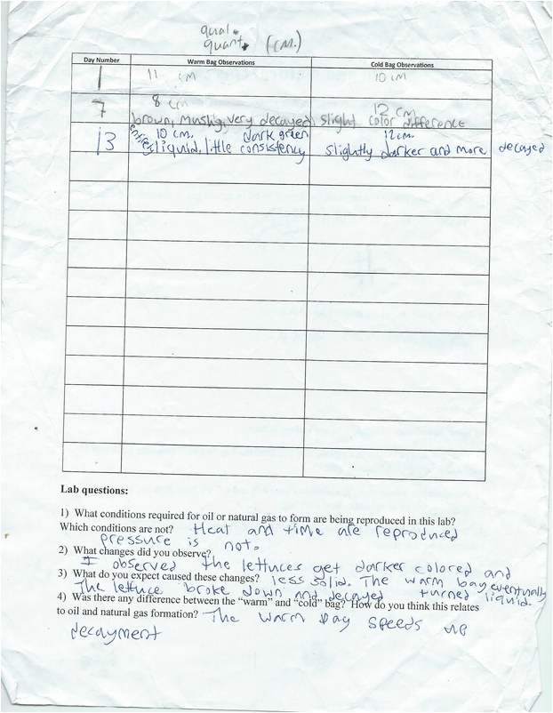
Cont. #4: ... , and thus the lettuce in the warm bag breaks down easily, but the cold bag lettuce does not decay fast and does not turn into liquid. In oil and natural gas formation, heat is required to make the fossils break down over time and form oil.
Seismic Exploration Lab
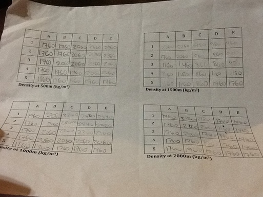
To better understand the process of finding and extracting oil, writing memos and research papers, and analyzing data from sound-systems, this past week we conducted a lab in which we searched and drilled for fake oil.
First, we were taught about how sound travels through different materials, and were told to come up with some kind of equation relating sound speed to density. Then, we were given "maps" of places at different depths in a fictional area, with the sound speeds of all the mini areas inside given. We calculated the density of the areas (shown in the above picture) with our equation
First, we were taught about how sound travels through different materials, and were told to come up with some kind of equation relating sound speed to density. Then, we were given "maps" of places at different depths in a fictional area, with the sound speeds of all the mini areas inside given. We calculated the density of the areas (shown in the above picture) with our equation
Second, we used our density maps to make maps showing where there may be oil and capping, where to drill for it, and then to create memos to a fictional project head at BP giving data and recommendations to create a final report.
The map is in the picture to the left. The memo is below:
BP Corporation
Int. Memo
To: Project Head
From: Developmental Analyst Grant
Date: 11-15-13
Subject: New data evaluation
Hello,
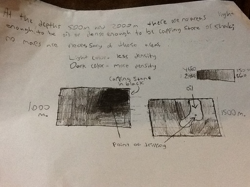
I have just finished evaluating the data you sent me about the potential oil-rich area our field workers have been exploring with sound systems. Data (taken from measured densities) indicates that our initial predictions were correct and there is a large oil reserve, beginning somewhere between the 1200 m. and 1400 m. ranges and extending downward to about 1900 m., in this area.
This reservoir is located in the lower-numbered D and E regions and the higher-numbered C regions of the area. Overall, this reservoir is expected to cover nearly nine regions. Enclosed is a rough map of the area depicting where the oil may be.
The drilling spot I would most highly recommend is in the middle of the D area, in the middle upper area of D3. This spot is marked in my map, but it is only a general suggestion of the exact spot. I chose this spot because of its location both near the center of the reserve area and in a place where the capping stone appears to be weak. Even so, drilling through areas of density approaching 2700 kg/m3, which could be shale, will be necessary, and the capping stone could be over 400 m. thick, beginning slightly above 1000 m. depth. It is thus recommended that drill teams use relatively powerful and very durable drills and equipment.
Approach this data with caution, as all figures mentioned are estimates and the densities of many regions are not specifically known. Also, before any drilling starts, sound-system teams should be instructed to find out where the capping stone and the oil reservoir begin, and to all around provide a better idea of what we can expect. However, I believe I have enclosed enough information for you write a decent basic report to the company.
The map is in the picture to the left. The memo is below:
BP Corporation
Int. Memo
To: Project Head
From: Developmental Analyst Grant
Date: 11-15-13
Subject: New data evaluation
Hello,
I have just finished evaluating the data you sent me about the potential oil-rich area our field workers have been exploring with sound systems. Data (taken from measured densities) indicates that our initial predictions were correct and there is a large oil reserve, beginning somewhere between the 1200 m. and 1400 m. ranges and extending downward to about 1900 m., in this area.
This reservoir is located in the lower-numbered D and E regions and the higher-numbered C regions of the area. Overall, this reservoir is expected to cover nearly nine regions. Enclosed is a rough map of the area depicting where the oil may be.
The drilling spot I would most highly recommend is in the middle of the D area, in the middle upper area of D3. This spot is marked in my map, but it is only a general suggestion of the exact spot. I chose this spot because of its location both near the center of the reserve area and in a place where the capping stone appears to be weak. Even so, drilling through areas of density approaching 2700 kg/m3, which could be shale, will be necessary, and the capping stone could be over 400 m. thick, beginning slightly above 1000 m. depth. It is thus recommended that drill teams use relatively powerful and very durable drills and equipment.
Approach this data with caution, as all figures mentioned are estimates and the densities of many regions are not specifically known. Also, before any drilling starts, sound-system teams should be instructed to find out where the capping stone and the oil reservoir begin, and to all around provide a better idea of what we can expect. However, I believe I have enclosed enough information for you write a decent basic report to the company.
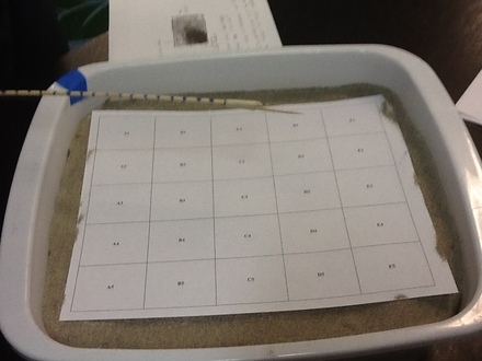
To test out whether our estimates for density and ideas for where to drill were correct, each table was given a box of sand with a map of the area we were supposed to be "analyzing" over it, given a toothpick, and to search for the "oil" that was underneath. My team drilled to the bottom twice and did not get any results, costing us 100 000 dollars in fake money for each centimeter drilled, amounting in a large amount of money lost. Finally, we drilled at D2 and struck oil.
Did your oil exploration and recovery efforts make money? Discuss variables you would want to change for more profitability.
Since we were also charged 225000 for each new drill location in addition to our drilling costs, and we made about 926000 dollars in oil profit, my table lost several hundred thousand dollars. To make more money, we should have been more accurate with our drilling, and picked a better recovery rate and oil volume, which we picked randomly and which determined our oil profit.
What aspects of this simulation were realistic? Which were not?
The random picking of oil volume and extraction were not realistic. Almost everything else, like the density maps, the memos, and the drilling costs, were realistic.
What was the purpose of this activity? What were some things you learned about oil exploration and extraction?
The purpose if this activity was to better understand the process of finding and extracting oil, writing memos and research papers, analyzing data from sound-systems, and using budgets. We learned that you need to convert sound system data into density maps in order to detect where oil is. We also learned that the costs of oil extraction depend on the price of oil, how deep you drill, how many times you drill, what size reservoir you reach and what your extraction rate is.
GNOME Oil Spill Modeling Lab
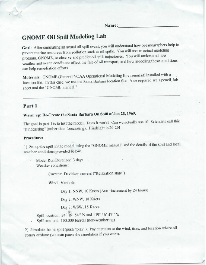
In this lab, we simulated oil spills using an oil spill modeling program used by the NOAA, known as GNOME (General NOAA Operational Modeling Environment) to simulate various oil spill situations, and learn about how oil spills work and how other factors such as weather affect them.
For the first part of the lab, we used the GNOME software to recreate an oil spill that happened off the coast of Santa Barbara. We were given data to simulate that spill, (shown in the image at right)
and put it into the GNOME simulator, then pressing play, and answering the following question:
1. Does the spill you modeled agree with the local account of the actual Santa Barbara oil spill (below). List some similarities and differences between the model and the observations of the actual spill:
Santa Barbara was experiencing a stormy winter, with a large flood event having occurred in January 25th, just three days before the blowout. Enormous amounts of freshwater were still running offshore from local streams, flowing south and southwest in the vicinity of the rig. Combined with the prevailing north-northwesternly winds typical pf the area between storm systems, this pushed the expanding oil slick away from the shore, and it seemed for a few days that Santa Barbara would be spared. However, another huge storm system affected the region on February 4th, with winds moving around the compass clockwise from southeast to west; this pushed the oil slick north into Santa Barbara harbor and onto all the beaches of southern Santa Barbara County and onto all the beaches of southern Santa Barbara county and northwestern Ventura county
In our simulation of the oil spill, most of the things we observed were similar. for instance, in both the simulation and the real event, the oil stayed in the same place for a period of time before being blown into Santa Barbara harbor. However, in real life, it took over a week for the oil to start going towards Santa Barbara harbor, while in our simulation, the oil was already starting to reach Santa Barbara by the end of the simulation, which only lasted three days. Aside from duration, though, there were no noticeable differences.
In the second part of the lab, we investigated what would happen if an oil spill took place today off the Santa Barbara coast, putting in a simulation for an oil spill occurring at the same location of the 1969 spill, on December 5th-7th, 2013, using the data on the picture at left, along wind speeds for the time period, which were as follows:
Day 1: NNW at 12 mph.
Day 2: SSE at 10 mph.
Day 3: WNW at 24 mph.
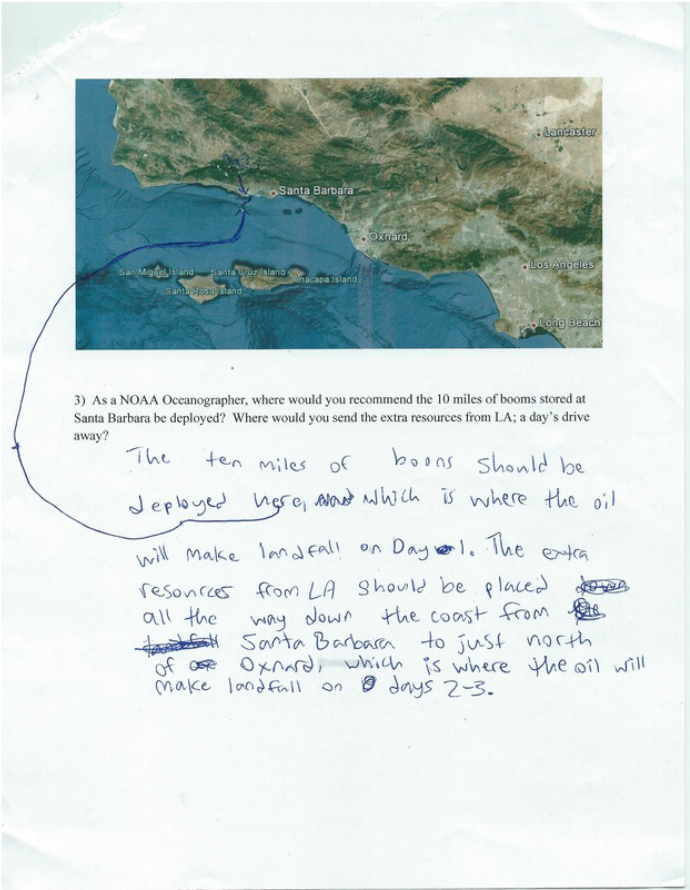
Then we were told to find where the oil would make landfall on day 1, and thus recommend where 10 miles of boons should be put before more cleanup materials from LA arrive in 24 hours, and where these materials should go, and we put the data into the system and hit play.
Day 1: NNW at 12 mph.
Day 2: SSE at 10 mph.
Day 3: WNW at 24 mph.
Then we were told to find where the oil would make landfall on day 1, and thus recommend where 10 miles of boons should be put before more cleanup materials from LA arrive in 24 hours, and where these materials should go, and we put the data into the system and hit play.
This is also the answer to question 2 on the earlier page.
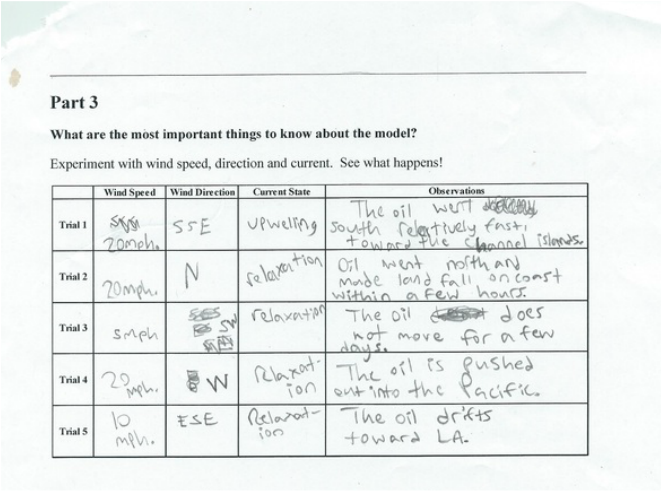
In part 3, we simply experimented in the GNOME program with several variables, and recorded our results, listed at right.
Finally, we were asked several questions about the lab and what we learned.
1. What are some of the most important variables in the model? Why are they important? Which do you think are the most important variables that determine where the oil will end up?
I think the most important factors in the model are wind direction and wind speed. These two are extremely important to where the oil will end up, and to the model in general, because wherever the wind goes the oil goes, and speed determines when it gets there.
2. What kinds of things changed when you made changes to the wind speed and direction? What happened when you changed the current?
When wind direction was changed the oil went in a different direction. When wind speed was turned up, the oil started moving faster, and the oil slowed down when we slowed the wind down. When the current changed, the oil's speed and direction changed a little bit, but not very much.
3. The Channel Islands have a very delicate marine ecosystem. What kinds of conditions would threaten the channel islands if an oil spill happened off Santa Barbara?
Quick south and south-southeastern winds would make the oil spill threaten the islands.
4. Although this model was used by NOAA, it is several years old. Newer versions take other versions into account. Can you think about other things that may effect how oil moves around that aren't modeled in this program that would improve accuracy?
Yes. Temperature might affect the oil spill, because it might change the speed of the oil. I think it is probably included in newer versions of GNOME.
